Beschreibung
iPhiGéNie is the tool of choice for outdoor maps in FRANCE, BELGIUM, Spain, Italy, Germany and Norway (NZ soon).
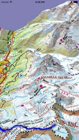
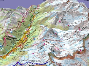
There are GPS applications with French topographic maps inside, iPhiGéNie brings you ALL maps from National Geographic Institute, with a GPS inside.
Privileged partner of IGNrando' website : access to a large tracks database.
• Maps display on the Apple Watch.
• 3D map display.
• Loaded maps avalaible OFF-LINE.
FRANCE: road maps are free, topographical maps are available on subscription (7 days free use trial).
Coordinates: géographic, UTM, MGRS, Lambert (I-II-IIe-III-IV,93), DFCI. Nautic units.
IN APP PURCHASES
* MODULE Vmax. Optional, permanent purchase. Adds extended features. See below.
* SUBSCRIPTION to Géoportail. Gives access to French topographics maps, photos, cadastral and more. Yearly. Recurring by default. See conditions below.
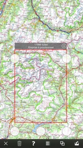
IMPORTANT: Every MAP displayed once IS KEPT ON THE DEVICE and is available even with no network (off-line mode). Also feature automatic bulk downloading on several layers and scales inside areas that you can define as you like.
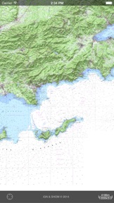
* OPTION French coastal maps (marine and terrestrial combo). Lasts one year.
* OPTION French aviation OACI map. Lasts one year.
All above options are available for ANNUAl subscription only..
* SUBSCRIPTION to Cartoweb. Gives access to topographic maps of BELGIUM. Not related to Géoportail subscription and options. Yearly. Recurring by default. See conditions below.
ESRI topographic wold coverage included in Geoportail subscription.
SPAIN, CATALONIA, NORWAY,ITALY, GERMANY: FREE topographical maps from national mapping authotity
NEW ZELAND coming soon
FREE WORLD-WIDE coverage though OpenTopoMap/OpenCycleMap.
On all these maps, iPhiGéNie displays your exact location.
* With optional Vmax module:
- 3D display.
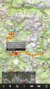
- Tracks and route: Recording, manual creation and editing, following, export-import in GPX file format.
- Waypoints/POI management, with photos: Add, file, annotate, export-import in GPX file format.
- Automatic downloading of maps along a predefined track.
- iCloud sharing for tracks and waypoints.
- Search address or any toponym present on a French map. Automatic creation of relevant waypoint.
- "GPS beacon" feature: People you authorize can follow your position on topographic maps. No tracking is done unless you activate it.
- Follow your friends beacon: Automatic update of followed positions. Very handful to find each other.
- One time purchase. Vmax module is a definitive purchase. You may use it with no Geoportal valid subscription, dispaying tracks and waypoints on available free maps.
Notes:
- GPS "beacon": Warning, you should never engage security on the availability of this feature.
- On iPod, no GPS position.
- GPS and battery lasting: the GPS is shut down when the application is sent to background, if there is no activated function requiring it (track recording, "GPS beacon"). Continued use of GPS running in the background can dramatically decrease battery lasting.
- English speaking users are welcome to ask any question in the English section of the forum on the support web site.
- Recurring subscriptions to map services
- Yearly subscription.
- Payment will be charged to iTunes Account at confirmation of purchase
- Subscription automatically renews unless auto-renew is turned off at least 24-hours before the end of the current period
- Account will be charged for renewal within 24-hours prior to the end of the current period.
- Subscriptions may be managed and auto-renewal may be turned off by going to the user’s Account Settings after purchase.
- No cancellation of the current subscription is allowed during active subscription period
- Any unused portion of the free trial period, will be forfeited when the user purchases a subscription to Geoportail map service.
- Privacy Policy : http://iphigénie.com/confidentialite.html
Neue Funktionen von Version 8.5
8.5
This autumn version brings native display on new iPhone models XS MAX et XR, as well as on Watch series 4.
New also are 4 Siri shortcuts (iOS 12). Most useful commands available from voice control.
Inverse geocoding for markers to retreive toponym, full address and cadastral reference from a position.
8.4.2
Fixes a regression preventing a recording track to display until the next scale change.
8.4.1
Fix for map image on the Watch not refreshing correctly.
8.4
This 2018 release implements a tightened partnership with IGNrando', the French IGN portal which lists hundreds of tracks and POI from institutional actors (reference data) or voluntary contributions.
Adding to already available features (import/export), it is no possible to :
• Log-in or create an account on IGNrando' website, without switching from iPhiGéNie
• Search fro tracks on currently displayed map span, or by township/district
• See found tracks on the map.
• Look at details of found tracks, with thumbnails
• Embark choosen tracks, one at a time from the details screen or by batch after selecting them in the results.
• Embarked tracks are instantly listed and available in the IGNrando' group.
• From this same IGNrando' group, it is easy as well to disembark choosen tracks.
Notes:
• Export of tracks from iPhiGéNie to IGNrando' was prviously done in public mode. It is now defaulting to private mode. You have to switch to public after completing exported tracks on IGNrando' website.
• Failure to export to IGNrando' when using non French language is now fixed.
8.3.2
Improvements :
• Adds position smoothing (predictive Kalman). 2017 iPhones were recording more noisy tracks than before. This smoothing reduce invalids position effects. It may be switched off from the Settings.
• Automatic consolidation of altitude values from the barometer and GPS. A significative improvement in altitude precision et tracks profiles.
• Adds a vertical speed value display, Vz, m/s, m/mn ou m/h
• Adds a Catalan translation, volonteer contribution by Miguel Rubio-Roy. Spanish-Castilian to come.
8.3.1
• Fixes location privacy settings for a regular usage with iOS 11.
• Adds screen images for iPhone X.
• Fixes a display format issue of the position in mesures toolbar.
8.3
This release brings iOS 11 and iPhone X compatibility. For technichal reasons, it can only be installed on iOS 9 and upward. iPhones 3GS and 4 can keep using 8.2.1 release.
• On iPads, this release brings "drag&drop" support to import GPX files. Droping files is possible on the main map view as well as on table list of tracks and markers. If droped on the map, the track (or the last one of the file if several) is instantly displayed.
• A minor change now display the distance to the next waypoint, in route following mode only, as the real distance rather than distance on the initial route.
8.0
- More features for the price ! With this new 2017 version, bulk maps downloading (former provisionnal cache option) is now included in the base subscription. All current valid subscriptions are retroactively entitled.
- User interface evolution for a quicker access to all buttons. One can choose buttons with or without labels. "Classic" UI is still available.
- Simplified automated export of tracks to IGNrando' web site (formerly Espace Loisirs IGN). Allow easy sharing or tracks between users and/or systems.
- Improved 3D quality by switching to 5m DTM from IGN.
- Improvement of GOTO waypoint function. More information in the buble, persistent on the screen.
- Improvements in the iWatch interface :
* Map pan with a finger
* Zoom with the crown
* Map center with a touch
* Center on next waypoint with a double touch
* New watch page for the GOTO waypoint